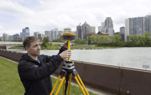
- Machine Guidance for Dredging
- Machine Guidance for Placement
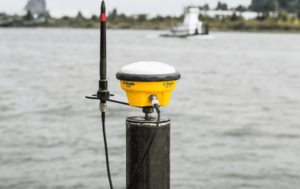
- GNSS Receivers and Antennas for Marine Construction
Machine Guidance for Dredging
Turn Data into Depth
Real-time guidance for precise and efficient dredging.


Achieve Greater Accuracy, Efficiency, and Safety
Enhance your dredging operations with real-time 3D visualization and precision guidance. Trimble Marine Construction Systems help you work smarter, reducing guesswork and rework while improving productivity and safety.
Maximize Marine Construction Success
Get the results you need from the start. Improve efficiency, minimize rework, and ensure every dredging task is executed accurately.
Key Benefits
Trimble Marine Construction Systems provide real-time positioning and guidance, enabling marine contractors to work with precision across various dredging methods—whether using backhoe excavators, clamshell cranes, cutter suction, bucket, or trailing suction hopper dredges.
Enhanced Operational Efficiency
- Improve dredging accuracy, site safety, and efficiency
- Reduce rework and complete projects faster
- Operate 24/7 with reliable system performance
- Ensure safer operations with improved situational awareness
- Quick, simple calibration with built-in functions
Real-Time Dredge Visualization and Guidance
- Monitor tool position, angle, and progress in 3D, plan, and profile views
- Color-coded Digital Terrain Model (DTM) highlights under- and over-dredged areas
- RTK GNSS ensures precise tide and heave measurement
- Continuous data logging for accurate as-built reports and volume calculations
- Supports real-time sonar inputs for as-building capabilities
Customizable Interface for Maximum Control
- Multiple screens with independent layouts tailored to operator needs
- Configurable workflow views locked for specific users
- Import realistic models from CAD software for enhanced visualization


Applications
Dredging
Maximize productivity with accurate GNSS positioning and 3D visualization. Set clear dredge tolerances for precise excavation and maintain efficient workflows with real-time data tracking.
Demolition
Safely and efficiently deconstruct bridgework, caissons, foundations, jetties, marinas, and more. Achieve greater precision with rock-breaking tools and single-pass debris recovery, even for small objects.
Trimble CenterPoint RTX Marine
Boost on-site productivity with Trimble’s real-time GNSS correction service. Achieve centimeter-level accuracy via satellite or internet, ensuring precise positioning for marine construction and survey applications. Trimble Marine Construction Systems empower your team with the tools to dredge with confidence—reducing costs, improving efficiency, and ensuring every cut meets project specifications.
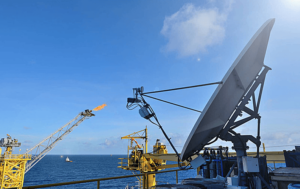
Machine Guidance for Placement
Precision Placement, Simplified
Improve efficiency with reliable underwater placement guidance.

Precision, Safety, and Efficiency in Material Placement
Enhance your marine construction projects with real-time 3D visualization and precise positioning. Trimble Marine Construction Systems empower operators to place materials and blocks with unmatched accuracy, reducing reliance on divers and increasing efficiency.
Optimize Marine Construction with Smart Placement
Achieve precise material placement for breakwaters, ports, bridges, and more. Improve efficiency, minimize rework, and ensure every placement is executed correctly the first time.
Key Benefits
Trimble Marine Construction Systems provide real-time positioning and visualization, enabling marine contractors to perform placement tasks with greater accuracy and confidence.
Enhanced Operational Efficiency
- Improve placement accuracy, safety, and overall productivity
- Reduce the need for divers in hazardous conditions
- Centimeter-level RTK horizontal and vertical placement accuracy
- 24/7 operation for continuous workflow
- Minimize rework and material waste
- Quick, easy calibration with built-in functions
Real-Time Visualization and Guidance
- View machine and material placement in plan, profile, and 3D
- Real-time numeric and visual guidance for precise underwater placement
- Tolerance visualization ensures accurate, efficient placement
- RTK GNSS provides precise tide and heave measurement
- Continuous data logging for as-built reports and volume tracking
Customizable Interface for Maximum Control
- Multiple screens with independent layouts tailored to operator needs
- Configurable workflow views locked for specific users
- Import realistic models from CAD software for enhanced visualization


Applications
Coastal Protection and Marine Infrastructure
Ensure accurate placement of materials and blocks for the construction and protection of ports, jetties, breakwaters, harbors, reefs, and marinas. Reduce project timelines and improve precision with real-time guidance.
Rock Dumping and Caisson Placement
Enhance efficiency in rock and caisson placement workflows with real-time visualization and positioning, eliminating errors and unnecessary rework.
Block and Pile Placement
Accurately place blocks using wire cranes or excavators, and ensure precise vertical and raked pile positioning for secure marine foundations.
Trimble CenterPoint RTX Marine
Boost your on-site productivity with Trimble’s real-time GNSS correction service. Achieve centimeter-level accuracy via satellite or the internet for reliable, precise marine construction and survey applications.
Smart Placement, Stronger Foundations
Trimble Marine Construction Systems deliver the precision and efficiency needed to streamline material placement, ensuring every structure is built to last with minimal rework and maximum safety.
GNSS Receivers and Antennas for Marine Construction
High-Accuracy GNSS for Any Marine Task
Accurate, real-time data for smarter marine operations.

Reliable Positioning for Smarter Marine Operations
Achieve precise positioning, heading, and attitude measurements with Trimble’s advanced GNSS receivers and antennas. Designed for onshore, nearshore, and offshore projects, these systems enhance accuracy, efficiency, and safety across marine construction workflows.
Precision GNSS for Every Marine Application
Trimble’s GNSS solutions provide real-time positioning, heading, pitch, and roll data, ensuring accurate execution of dredging, rock placement, pile driving, and other marine construction tasks. With support for multiple correction sources—including Trimble CenterPoint RTX—you get centimeter-level accuracy anywhere.
Key Benefits
- High-Accuracy Positioning – Real-time GNSS corrections for precise horizontal and vertical placement.
- Reliable Heading & Attitude Data – Dual-antenna systems ensure accurate orientation and movement tracking.
- Seamless Connectivity – Integrated 4G/LTE, Wi-Fi, and Bluetooth for remote access and file sharing.
- Optimized for Harsh Environments – Rugged, compact designs built for marine construction conditions.
Advanced GNSS Solutions for Marine Construction
MPS566 Modular GNSS Heading Receiver
A high-precision dual-antenna GNSS receiver delivering accurate heading and position data for dredging, rock placement, and vessel positioning.
- Compact design with reduced power and cabling requirements.
- Real-time heading and attitude measurements for marine operations.
- Cellular hotspot functionality for easy data transfer.
R750 GNSS Modular Receiver
An advanced GNSS receiver designed for base-station applications in marine construction.
- Tracks all known GNSS constellations in dynamic environments.
- Supports multiple correction sources, including radio and satellite-based signals.
- Internal radios reduce cabling and simplify setup.
BX992 GNSS Receiver
A dual-antenna GNSS receiver delivering scalable accuracy up to the centimeter level.
- Precise heading and attitude data for positioning and dredging.
- Compact, rugged design for demanding marine conditions.
- Supports Marinestar and Trimble RTX services for high-accuracy positioning.
R780 GNSS Smart Antenna
A robust and versatile smart antenna designed for site positioning and RTK base station applications.
- Integrated Wi-Fi, Bluetooth, and dual-band radio for expanded connectivity.
- Ideal for hydrographic surveys and nearshore marine construction.
Seamless Integration with Marine Construction Workflows
Trimble GNSS receivers and antennas work seamlessly with Trimble Business Center and Trimble Marine Construction software, ensuring real-time 3D visualization, accurate positioning, and improved workflow efficiency.
Applications include:
- Rock and block placement for breakwaters, jetties, and harbors.
- Dredging and excavation with precise material removal tracking.
- Pile driving and caisson placement for marine infrastructure.
- Hydrographic surveys and real-time depth measurement.
Boost Productivity with Trimble CenterPoint RTX Marine
Enhance your GNSS performance with Trimble CenterPoint RTX—delivering real-time, centimeter-level accuracy via satellite or internet, eliminating the need for a local base station.
Achieve Unmatched Accuracy in Marine Construction
Trimble’s GNSS receivers and antennas provide the precision, reliability, and connectivity needed for marine projects of any scale. Reduce rework, improve efficiency, and build with confidence.